A 1.5 mile hike through the heart of Austin that explores how floods have shaped over 200 years of the city’s history

6th & Lamar
Austin drew a relatively good lot when it comes to natural disasters, but floods have always plagued the city. Flash floods, specifically. The type that transforms an innocent looking ditch into a torrent of churning whitewater capable of ripping oak trees out of the ground and carrying cars for miles. It’s a deadly threat that has tested every generation of residents and scarred the city.
This hike explores the profound impact floodwaters have had on the development of the city by following the monuments and markers hidden in plain sight. We start at the corner of 6th and Lamar looking towards downtown with the flagship Whole Foods Market on our right. The original Whole Foods was located a few blocks from here, before falling victim to the great Memorial Day Flood of 1981 – a disaster that nearly ended the business.
In the earliest days of Austin, this was the wilderness. The original town grid was nestled in a section of land bordered by the Colorado River on the south, Waller Creek on the east, and Shoal Creek on the west. All three are prone to violent flooding and created natural barriers to further expansion. We are here to see the bridge over Shoal Creek.
West Sixth Street Bridge at Shoal Creek

There’s not much to see from street level, most Austinites cruise past the squat stone walls without even registering they are on a bridge. To understand how revolutionary this structure was in its time you have to descend from street level to the shores of the creek. From here you can see the three stone arches carved from heavy limestone and planted firmly on the bedrock. In the northwest corner there is a simple historical marker that has been battered and chipped with time. Enough to hint at the significance without divulging any of the secrets.
What it doesn’t tell us is that the US Army built the first bridge in Austin at this location in 1865. That one was a narrow iron footbridge that was incapable of carrying wagons or horses. It’s likely that America’s first serial killer used it when he slink in under the cover of darkness and brutally murder Mollie Smith using an axe. But, it wasn’t sufficient in bringing city services to the area and in 1887 the city council approved construction of a vehicular bridge. It was completed later that year and has withstood decades of floods and stands relatively unchanged to this day.
The bridge extended the main thoroughfare of Pecan Street (later renamed 6th Street) into the western part of the city. Pecan Street’s prominence was also a byproduct of flooding. It was the northernmost street from the Colorado River (and therefore safe from flooding) that was flat enough to carry wagons. Businesses were safe setting up shop there and it developed alongside Congress as the two main commercial avenues that carried city expansion*.
*Note that the bridge is built to the specific width of the roadway so there is not a narrowing. This was an extension of the 1839 master plan and allowed the city to expand following the original blueprint.
Shoal Creek Trail

We’ll follow the creekside trail south towards the river. After we cross under 5th Street we get a view of the battlements our generation has erected to battle the waters. The high concrete walls and stacked stone blocks are designed to prevent erosion and swiftly usher flood waters into the Colorado River and towards the Gulf of Mexico. Take a moment to imagine the force behind a wall of water that extends to the top of the wall and notice how all the vegetation in the creek bed is flattened by the flow of water. Keep an eye on the creek to see what kind of debris was carried by the water.
We’ll continue following the winding path and then admire the delicate arches of the Butterfly Bridge as we cross into the heart of downtown. The East side of the bridge disappears into a steep canyon created by the towering Google Tower on one side and the Proper Hotel on the other. To this day, the creek is a soft boundary between the dense downtown districts and the surrounding central neighborhoods.
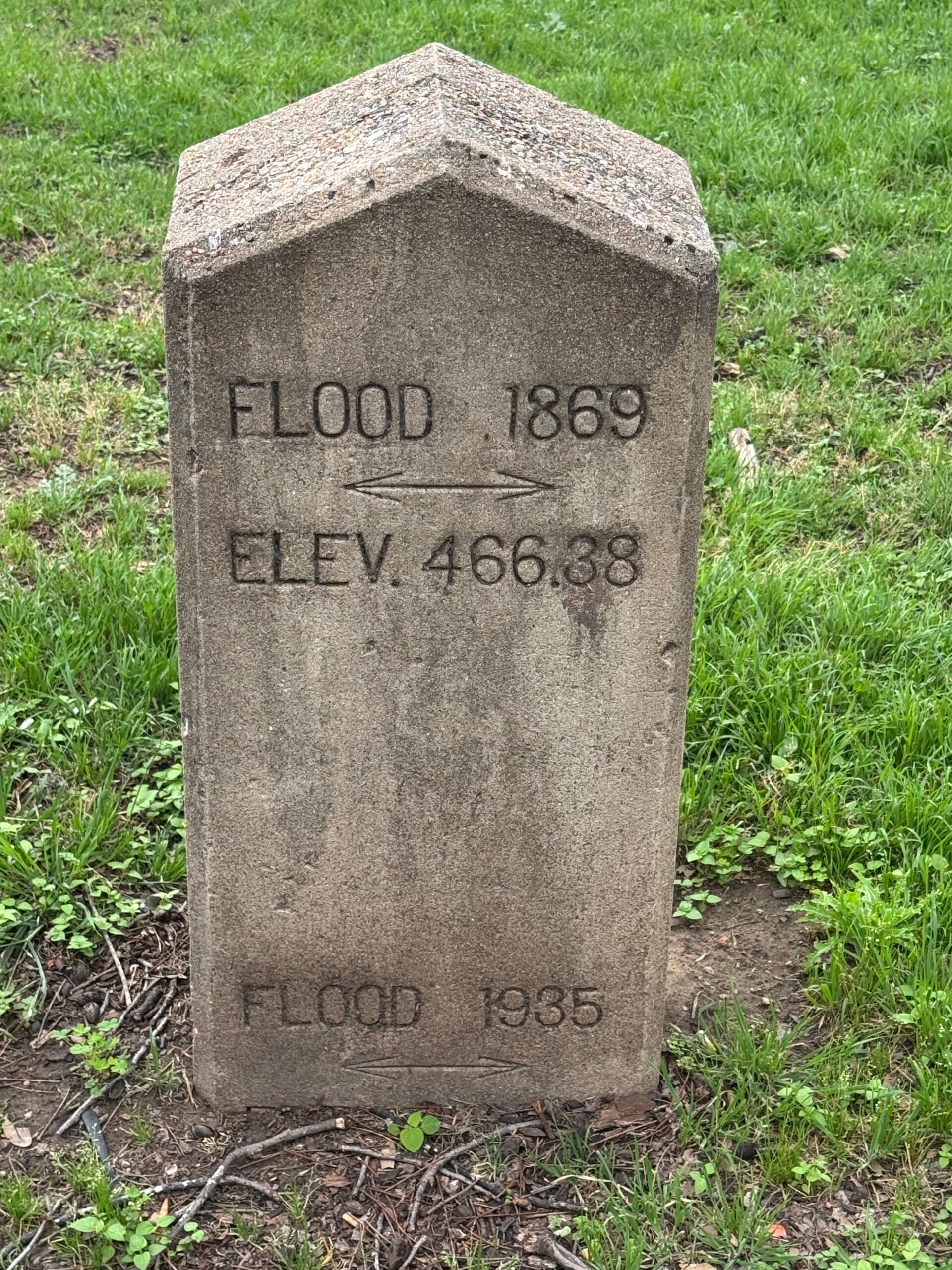
High Water Mark

We are headed to an easily overlooked public art installment on the sidewalk across from City Hall called High Water Mark. The exhibit consists of a collection of photos woven into the sidewalk railing that document devastation from decades of flooding. Look carefully and you will spot the West 6th Street Bridge in different decades. Interestingly, the installation isn’t meant as a memorial, but rather as an acknowledgement of the personal impact the repeated flooding has had on Austinites.
The photo exhibit was installed in 2008, but it was inspired by a much older monument that juts from the grass like a pauper’s grave near the old fire tower. Etched into the concrete marker are the high water marks from two of the city’s historical floods. They are the dates that are inscribed in antique script on the corners of many of the photographs we just examined.
Also in the vicinity is a plaque commemorating the inauguration of the Town Lake Beautification Project. On this site former president LBJ helped plant the first of hundreds of trees the project sponsored as part of their mission to transform the trail into a crown jewel of the city. We will descend to lake level and follow the hike and bike trail that was also installed as part of the beautification project.
Lady Bird Lake

If you’ve been paying attention, you’ve noticed I alternate between calling this body of water a river and a lake. It’s both. Technically, it is the Colorado River, but not the famous one. It’s a smaller river with the same name that only exists within the borders of Texas. In 1960, the city constructed and created the downtown lake. A new lake called for a new name. Lake Longhorn was the leading contender. It was being pushed by the chamber of commerce, who also envisioned turning the area into an urban playground with sandy beaches and speed boats.
The City Council delayed naming the lake, but by 1962 they had kicked the can to the end of the road and assigned a lake study committee to suggest a proper one. It was a grand plan, until the committee came back with Lake Tonkawa and ignited a fierce debate. While some citizens thought that it was a romantic name and a fitting tribute to the history of the area, others thought it was hard to pronounce.
The City Council were among the citizens who struggled with pronunciation, so they unanimously rejected Lake Tonkawa in favor of the colloquial Town Lake. The only dissent came from Councilman Bob Armstrong who thought the name was too generic, so advocated for the more descriptive name of Austin City Lake. The mayor said it didn’t matter what we named it, folks were going to call it Town Lake regardless. Maybe he was right, a lot of folks still do.
The lake was a functional one, necessitated by the power plant needing a cooling reservoir, but it was pitched to the city as the beginning of “one of the nation’s most beautiful downtown waterfront areas.” A decade later things hadn’t turned out that way. The lake was an eyesore. It was surrounded by bushy shrubbery and tall grass. Worse, locals used it as a dumping station and there was trash floating in the water.
Lady Bird focused her influence on the Town Lake Beautification Project, and transformed the lake into a crown jewel for the city. They planted hundreds of trees and built a hike and bike trail that loops the lake. After her death in 2007, the City Council voted to rename the lake in her honor, both as a memorial and reminder for future generations. “It would dishonor Lady Bird and her family if we name Town Lake after her and don’t continue to protect and improve the area,” councilman Mike Martinez proclaimed. It’s a living project and the lakefront continues to evolve as a feature of downtown.
Waller Creek

Our final spot is a demonstration of the improvement projects and evolutions that are continuing along the lakefront. At the time of this writing, the confluence where Waller Creek joins the Colorado River is a construction zone. Three bridges are being built (one is completed) to span Waller Creek, the original eastern border of the settlement.
On the other side of the creek towers stretch towards the sky and when completed the tallest building in the city will be east of Waller Creek for the first time in city history. The Rainey Street district where the towers are situated has undergone an incredible transformation. In 2005 it was a quiet neighborhood on a secluded side street. Then, zoning changes allowed businesses to operate from the homes. Cocktail bars sprouted in converted houses sprinkled throughout the neighborhood. Then, it was all the houses and Rainey Street took over as the main entertainment zone.
It wasn’t meant to last, and bars were bulldozed to make way for condo towers. There are still a few bars sprinkled on the street to remind us of the brief heyday. It’s a good place to end and find a cocktail and seat. It’s 1.5 miles or a short uber ride back to the start from here. You can either retrace our route, or stick to the city streets, 2nd Street is the most pleasant one to walk and will take you by the Willie Nelson statue and a number of cafes and coffee shops.